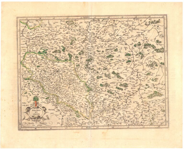
19. POLONIA ¦ ET ¦ SILESIA
Grodecki (Grodeccius, Grodeccio) Waclaw (Wenceslaus) (+1591)
Hondius Henricus (Henry, Hendrick, Henricum) (1597-1651)
Hondius Jodocus (Jodoci) (Hondt, Josse de) (1563-1612)
Janssonius (Jansson, Janssen, Johnson) Jan (Johannes, Joan) (1588-1664)
Mercator (Kremer, Cramer) Gerard (Gerhard) (1512-1594)
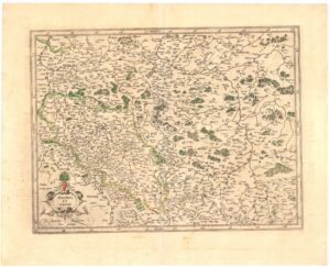
Skala 1:2460000
Miedzioryt , kolorowany kartusz i lasy, mapa ogólnogeograficzna.
Gerardi Mercatoris atlas sive cosmographicae meditationes de fabrica mundi…a judoco Hondio. Amstelodami 1609 excusum in aedibus J. Hondii.
Przeróbka mapy W. Grodeckiego wykonana przez G. Mercatora i wydana po raz pierwszy w Duisburgu. Zamieszczana wielokrotnie i w różnych wersjach w atlasach J. i H. Hondiuszow oraz J. Janssona. Alternatywny tytuł atlasu: „Iam tandem ad finem perductus, quamplurimis aeneis tabulis Hispaniae, Africae, Asiae et Americae auctus ac illustratus a Iudoco Hondio. Quibus etiam additae (praeter Mercatoris) dilucidae et accuratae omnium tabularum descriptiones nouae, studio et opera Pet. Montani, Gerardi Mercatoris atlas sive cosmographicae meditationes de fabrica mvndi et fabricati figvra, and Mercatoris Atlas 1609”. Inni kontrybutorzy wydania atlasu: Mercator, Rumold, approximately 1545-1599, Mercator, Gerard, approximately 1565-1656, Mercator, Michael, -1600, Llwyd, Humphrey, 1527-1568, Keere, Pieter van den, 1571-approximately 1646, Fayen, Antoine Jean du, approximately 1530-approximately 1616, Bompar, Pierre, La Guillotière, François de, Doetichum, Baptista van, -1611, Mercator, Johannes, approximately 1562-1595, and Lubin, Eilhard, 1565-1621Pod kartuszem podpis G. Mercatora: „Per Gerardum Mercatrum ¦ Cum privilegio„. Opisane strony świata: Septentrio, Meridies. Na SE ołówkiem: „267”, na NW: „116”. Na odwrocie tekst: „LE ROYAUME DE POLOGNE.„, „LE ROYUAME DE POLOGNE”, na NE numer strony: „281”, na NW „282”, na SE: „Ffffff”, ołówkiem: „Mercator ¦ 1630¦ 34˝ x 45˝ cms”
Rzeźba: kopczyki
Osiedla: sygn. obrazkowa, kółka
Hydrografia: rzeki, jeziora
Nazewnictwo: hydrografia, państwa, prowincje, osiedla
Współrzędne geograficzne: opisane między ramkami co 1°, oznaczone graficznie w ramce wewnętrznej co 2′
Ramka: zwykła
Format: r: 343×454, p: 347×458, a: 444×556
Kolekcja: Roman Umiastowski
Nr katalogu CRP: 00256-11423
ⓒ Piotr Maria Mojski (B. de Weydenthal)