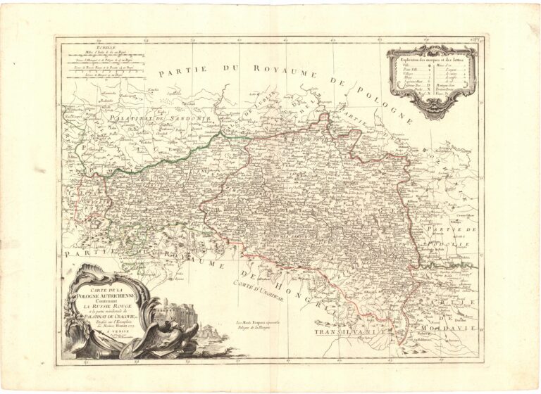
16. CARTE DE LA | POLOGNE AUTRICHIENNE | Contenant | LA RUSSIE ROUGE | et la partie méridionale du | PALATINAT DE CRACOVIE, etc | Dressée sur l’Exemplaire | des Harities Homann 1775. | A VENISE | Par P. Santini 1776. | Chez M. Remondini.
Bellin Jacques Nicolas (1703-1772)
Bonne Rigobert (1729-1794)
Homann Hered (Heirs, Hereties, Homannischen Erben) (1730-1813)
Janvier Sieur (XVIII w.)
Remondini M. Giuseppe Antonio (1747-1811)
Robert de Vaugondy Didier (1726-1786)
Robert de Vaugodny Gilles (1688-1766)
Santini P. François (XVIII w.)
Skala 1:1000000; skala przybliżona, podziałki liniowe: „ECHELLE„, „Milles d’Italie de 60 au Degré„, „Lieues d’Allemagne et de Pologne de 15 au Degré„, „Lieues de Russie Rouge et de Pocutie 11/4„, „Lieues de Hongrie 19 au Degré„
Miedzioryt, kolorowane granice prowincji, mapa topograficzno – gospodarcza.
Atlas Universal… par Janvier, Bellin, Robert [Gilles], Robert de Vaugondy, Bonne. A Venise 1778 chez P Santini.
Mapa opracowana w oficynie spadkobierców Homanna w 1775 roku, następnie zamieszczona w atlasie P. Santiniego. Na NE w treści legenda miejscowości, struktury administracyjnej i kopalni: „Explication des marques et des lettres”, między ramkami: „P.I. 47”. Na odwrocie na SE ołówkiem: „Santini P. – Homann 1776 45 x 581/2 cms„.
Znak wodny: R
Rzeźba: kopczyki
Osiedla: sygnatura obrazkowa, plany, kółka
Hydrografia: rzeki
Nazewnictwo: hydrografia, państwa, prowincje, regiony, 4-st. osiedla
Ramka: zwykła
Format: r: 450×588, p: 459×600, a: 533×741
Kolekcja: Roman Umiastowski
Nr katalogu CRP: 00456-36951
ⓒ Piotr Maria Mojski (B. de Weydenthal)