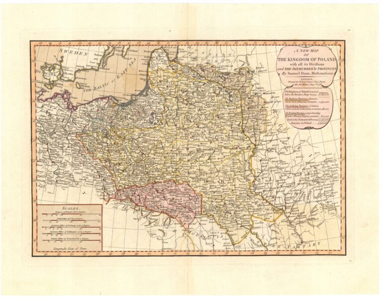
204. A NEW MAP ¦ OF ¦ THE KINGDOM OF POLAND ¦ with all its Divisions ¦ and THE DISMEMBED’D PROVINCES ¦BySamuel Dunn, Mathematician
Dunn (Dun) Samuel (+1794)
Jefferys (Gefferys) Thomas (1710-1771)
Kitchen (Kitchin) Thomas (1718-1784)
Sayer Robert (1725-1794)
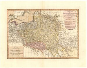
Skala 1:4000000; skala przybliżona, podziałki liniowe: „SCALES„, „Leagues of Poland 28 in a Degree.„, „British Miles 68½ in a Degree.„, „Common Miles of Germany 15 in a Degree.„, „Common Miles of Lithuania 20 in a Degree„, „Statute Miles of Prussia 18 in a Degree.„.
Miedzioryt, kolorowane granice, mapa polityczna.
A General Atlas… by Samuel Dunn, Robert Sayer and Thomas Jefferys. Londyn 1786
Mapa opracowana i wydana przez R. Sayera przy współpracy angielskiego matematyka i wydawcy S. Dunn’a. Samuel Dunn (zm. 1794) był brytyjskim matematykiem i astronomem amatorem. Pochodził z Crediton w hrabstwie Devonshire. Jego ojciec zmarł w Crediton w 1744 r. W swoim testamencie napisał: W 1743 r., Kiedy pierwszy wielki pożar wybuchł i zniszczył zachodnie miasto, przez pewien czas prowadziłem szkołę i uczyłem pisania, rachunków, nawigacji i innych nauk matematycznych. chociaż nie ukończył dwudziestu lat; potem przeniosłem się do szkoły u stóp Bowdown [obecnie Bowden] Hill i nauczałem tam do Bożego Narodzenia 1751 roku, kiedy przyjechałem do Londynu. Szkoła była miejscem, w którym „szkoła angielska” była utrzymywana wcześniej w związku z niebieską szkołą w 1821 r. W Londynie Dunn nauczał w różnych szkołach i udzielał prywatnych lekcji. W 1757 roku stanął przed opinią publiczną jako wynalazca „uniwersalnych planisfery, czyli ziemskich i niebieskich globusów w plano”, czterech dużych map stereograficznych, z przezroczystym indeksem umieszczonym nad każdą mapą, dzięki czemu okręgi sfery są natychmiast rzutowane na płaszczyzna południka dla dowolnej szerokości geograficznej oraz problemy geografii, astronomii i nawigacji opracowywane z taką samą pewnością i łatwością, jak przez same globusy, bez pomocy skali i kompasów, pióra i atramentu. Opublikował opis ich opisu i zastosowania, wydanie 2, octavo, Londyn, 1759. Z przedmowy wynika, że w 1758 r. Dunn został mistrzem akademii „zajmującej się przyjmowaniem na pokład i kwalifikowaniem młodych dżentelmenów w dziedzinie sztuki, nauk ścisłych i języków. i dla biznesu ”, w Chelsea. To było w Ormond House, gdzie było dobre obserwatorium. W dniu 1 stycznia 1760 r. Dokonał obserwacji niezwykłej komety , inne odkrycia przekazał Royal Society. Pod koniec 1763 roku porzucił szkołę w Chelsea i po raz kolejny powrócił do prywatnego nauczania w Brompton Park, niedaleko Kensington. W 1764 r. Odbył krótkie tournee po Francji. W 1774 roku, mieszkając w 6 Clement’s Inn, niedaleko Temple Bar, opublikował swój doskonały Nowy Atlas Systemu Przyziemnych, czyli Geografii i Kosmografii, opisujący Niebiosa i Ziemię. Całość elegancko wygrawerowana na sześćdziesięciu dwóch miedzianych płytach. Z ogólnym wprowadzeniem, folio, Londyn. Mniej więcej w tym czasie jego reputacja doprowadziła do mianowania go egzaminatorem matematycznym kandydatów do służby w Kompanii Wschodnioindyjskiej. Pod patronatem firmy mógł opublikować w przystojnej formie kilka swoich ważniejszych prac. Były to: A New and General Introduction to Practical Astronomy, with its application to Geography… Topography, octavo, London, 1774. The Navigators Guide to the Oriental or Indian Seas, or the Description and Use of a Variation Chart of the Magnetic Needle, zaprojektowany do pokazywania długości geograficznej w głównych częściach Oceanu Atlantyckiego, Etiopskiego i Południowego, octavo, Londyn (1775). Nowy przykład praktycznej nawigacji, czyli Przewodnik po morzach indyjskich, zawierający (1) elementy nauczania matematycznego, używane… w teorii i praktyce żeglarskiej; (2) Teoria nawigacji. ..; (3) Metoda korygowania i określania długości geograficznej na morzu…; (4) Praktyka nawigacji we wszystkich rodzajach żeglarstwa (z miedzianymi płytami), octavo, Londyn, 1777 oraz Teoria i praktyka długości geograficznej na morzu… z miedzianymi płytami, octavo, Londyn, 1778; wydanie drugie, powiększone, quarto, Londyn, 1786. On także „opracował, poprawił i rozszerzył” dobre quarto, zatytułowane A New Directory for the East Indies… będące dziełem pierwotnie rozpoczętym na planie Wschodniego Neptuna, rozszerzonym i ulepszone przez Herberta Willma. Nichelson i inni, Londyn, 1780, który osiągnął piątą edycję w tym samym roku. Dunn mieszkał przy 8 Maiden Lane w Covent Garden w lipcu 1777 r., Ale do września 1780 r. Zamieszkał przy 1 Boar’s Head Court, Fleet Street, gdzie mieszkał do końca życia. Mapa świata autorstwa Samuela Dunna, 1794, z mapami gwiazd, mapą Księżyca, mapą Układu Słonecznego i wieloma innymi cechami. Zmarł w styczniu 1794 r. Jego testament, datowany 5 stycznia 1794 r., Został udowodniony w Londynie 20 stycznia przez jego krewnego Williama Dunna, urzędnika akcyzowego Londynu (zarejestrowany w P.C.C., 16, Holman). W nim określa siebie jako „nauczyciela matematyki i mistrza długości geograficznej na morzu” i pragnie być pochowany „w kościele parafialnym należącym do miejsca, w którym będę przebywał na krótko przed śmiercią”. Wymienia siedem krewnych, którym zostawił po 20 funtów; ale jego żonie, Elizabeth Dunn, „która odsunęła się ode mnie przez blisko trzydzieści lat, za sumę zaledwie dziesięciu funtów”. Żadne dzieci nie są wymienione. Poprosił również korporację Crediton, aby zawsze zapewniała i miała mistrza szkoły u podnóża Bowden Hill, który tam mieszkał, kościoła anglikańskiego, ale nie święceń, zdolnego nauczyciela pisania, nawigacji, księżycowej metody. Robert Sayer (1725–1794) był czołowym wydawcą i sprzedawcą druków, map i map morskich w gruzińskiej Wielkiej Brytanii. Mieszkał w pobliżu Golden Buck na Fleet Street w Londynie. Jego brat James poślubił owdowiałą Mary Overton, synową drukarza Johna Overtona. Sayer została jej asystentką, aw 1748 r. Została nazwana menadżerem Golden Buck iw ten sposób stopniowo przejęła istniejącą firmę Overton jako kontynuującą działalność. Przeniósł się do atlasów i innych prac kartograficznych, publikując Mundane System (1774) Samuela Dunna i słynnego pilota północnoamerykańskiego (1775), który zawierał ważne mapy wykonane przez wielkiego podróżnika i odkrywcę, kapitana Jamesa Cooka. Sayer zorganizował grawerowanie obrazów niektórych czołowych artystów tamtych czasów, przede wszystkim Johana Zoffany RA, i sprzedawał odbitki z rycin. W ten sposób pomógł zabezpieczyć międzynarodową reputację Zoffany’ego. Sayer i artysta stali się wieloletnimi przyjaciółmi i współpracownikami. W 1781 roku Zoffany namalował Roberta Sayera w ważnym „artykule konwersacyjnym”. Rodzina Sayerów z Richmond przedstawia Roberta Sayera, jego syna Jamesa z pierwszego małżeństwa i jego drugą żonę, Alice Longfield (z domu Tilson). Za grupą rodzinną stoi ogromna willa na Richmond Hill z widokiem na Tamizę, zbudowana dla Sayera w latach 1777-1780 według projektów Williama Evesa, mało znanego architekta i dewelopera. Od 1794 roku, po śmierci Roberta Sayera, dom był przez trzy lata wiejską rezydencją księcia Clarence (późniejszego króla Wilhelma IV) i pani Jordan oraz trójki ich najstarszych (z dziesięciorga) dzieci. W domu urodziło się trzecie dziecko. Zrujnowany dom został zburzony w 1970 roku, kiedy nie wiadomo było, że został zbudowany dla Sayera, a następnie był domem przyszłego króla Wielkiej Brytanii. Tekst na SW między ramkami: „Longitude East of Londyn„, W kartuszu tytułowym pod tytułem: „Londyn; ¦ Printed for Robert Sayer, Fleet Street, ¦ as the Act divects, August, 1st. ¦ 1786.„, Ponizej: „The Kingdom of Poland Contain’d ¦ before the Partation Treaty in 1775.. (Inhabitants) 14,260,000„, „The Russian Province, dismem-¦bered from Lithuania, contains… (Inhabitants) 1,550,000„, „The Austrian Province, of Galicia ¦ which includes Lodomeria, contains…. (Inhabitants) 2,580,000„, „The Prussian Province, coMuzeum Polskie w Rapperswiluehending ¦ Polish or West Prussia & C. contens… (Inhabitants) 800,000„, „Total in the dismemberd Provinces 4,930,000„, „Remains in Poland 9,330,000.„. Na SE i na NE numery strony „12„.
Na odwrocie na NE: „M brak” na SE ręcznie ołówkiem: Polska Sayer – Dunn 1786″.
Rzeźba: kopczyki
Osiedla: sygnatura obrazkowa, kółka
Hydrografia: rzeki, jeziora, bagna
Komunikacja: drogi
Nazewnictwo: hydrografia, państwa, regiony, osiedla
Współrzędne geograficzne: opisane między ramkami co 1°, oznaczone graficznie w ramce wew netrznej co 10′.
Ramka: zwykła
Format: r: 303×444, p: 331×466, a: 417×534
Kolekcja: Roman Umiastowski
Nr katalogu CRP: 00321-36816
ⓒ Piotr Maria Mojski (B. de Weydenthal)